A “derecho” is a large meso-scale convective weather system that usually takes on the shape of a boomerang and can be hundreds of miles wide. They will typically advance at high speed for hundreds of miles across many states spreading very high wind out ahead of the edge of the line. The Ohio Valley commonly sees these in the summer months, with lots of wind damage as a result.
The computer modeling has been hinting for days now that a storm of this type will form near Iowa and then head southeast into the middle and/or upper Ohio Valley Wednesday night into Thursday morning. The first concern is: will this storm actually form as predicted? There are a couple of points that might prevent this. Dewpoints are only mildly high with readings in the upper 60s and low 70s and these may fall slightly as we head into this afternoon. Secondly, upper flow is not particularly strong in this area. So we’ll have to wait until afternoon and see if this derecho actually does form. If it does, the second concern obviously will be its path. What path will it take?
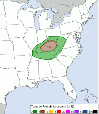
Currently, the Storm Prediction Center is thinking that the storm will move largely eastward, and will affect Indiana and into Ohio and then West Virginia. There is an outside chance that it could track slightly farther southward which would pull northern Kentucky into the mix as well. Here is the current outlook from SPC for the possibility of wind damage tonight:

None of the high resolution models are currently showing the derecho affecting Kentucky. What they do show is a line of storms connected to the derecho back-building down the Ohio River. This line of storms would then sweep across Kentucky late tonight and would pose a lesser, but still possibly severe, threat to central Kentucky. The NAM-WRF model shows this well:

Everyone along and north of I-64 needs to pay special attention to the weather conditions tonight. This has the potential to be a very damaging event for a great number of people. NOAA weather radio is the best way to receive warnings and watches. If you use a smartphone, I have found Weatherbug to be the best app. The NWS websites are also the best places for weather forecasts and info. http://www.weather.gov/louisville
-Shawn


