Thursday, July 26, 2012

Severe Weather in Kentucky Tonight


The 105°F heat index readings are going away today.  This weekend should be very normal for this time of year with beautiful summer weather.  But the transition from miserable to normal isn’t going to happen easily.  A round of severe weather is going to explode today across much of the eastern half of the nation, primarily in the Ohio Valley and into New England.

We have just about all the ingredients to make the cake that we need.  Instability is VERY high (up to 4,000 joules per kilogram!)  The surface is being heated by the sun uninhibited by clouds.  Temperatures are in the 90s to near 100 by afternoon, creating strong lapse rates.  There is decent wind shear of 40-50 knots.  We’ve got lift in the form of a cold front approaching the area.  Dewpoints are running in the 70s so water vapor content for fuel is plentiful.  Basically, this is a prime recipe for severe thunderstorms.

Here is the current wind damage outlook from the Storm Prediction Center:


As you can see, northern sections of Kentucky, basically north of I-64, are in the 30% range.  Cincinnati is in the hatched area, where “significant” wind damage may occur.  Anyone inside the red zone on this chart needs to pay special attention to the weather today.

I think the timeframe we’re looking at is from about 17:00 (5pm) through midnight.   Many of the models are showing convection holding off here until well after dark.  The Hi-Res NAM doesn’t really get things going here until 2:00 tomorrow morning.  But I think that we’ll see a very active squall line threatening Kentucky before sunset tonight. 

In this setup, tornadoes are not a major threat to Kentucky.  Wind damage and flash flooding will be the biggest problems here.  Remember, the #1 killer in thunderstorms is WATER.  Floods kill more people annually than lightning or twisters.  If you see running water across a roadway, do not drive through it, even if you have a Jeep.  It’s tempting, I know.  But don’t do it.  Moving water has significant power.

Keep the NOAA weather radios on today and keep your eyes peeled.  We had storm fatalities in KY last week...let’s have zero this week.


-Shawn

Monday, July 9, 2012

Where is the Kentucky rain?

So when is it going to rain?  That’s the question on everyone’s mind now that Lawrenceburg finds itself firmly in drought conditions.  We saw 0.75” of rain last weekend, but since then we’ve received only a trace of rain, while Harrodsburg, Danville, Lexington, Winchester, and Georgetown have all seen soaking thunderstorms.  In a year that showed no seasonal signs of an impending drought, we are now in the midst of a fairly serious situation which has also been compounded by a record-setting heat wave.  So, what gives?  When is it our turn for some rain?


First of all, we can at least be thankful the heat wave is gone.  As of yesterday, July 8, 7 out of the last 11 days saw the air temperature reach 100-104 degrees.  To have this happen beginning in June is record setting in itself.  On Sunday the heat index reading in Lawrenceburg briefly touched 114 degrees.  To say that it’s been miserable lately would be an understatement.  Thankfully, a cold front is working through the state today, and the 100 degree air is gone and doesn’t look to return anytime soon.


As far as precipitation goes, I suppose we must be happy for our neighbors who all received good rains from the recent storms.  Every county in Kentucky can use the rain, and so whoever gets it is fortunate.  Going through the remainder of this week, it appears that Friday is our best shot at some rain here in Anderson County.  Stuck between a couple of ridges, we should find ourselves in a favorable environment to generate some rain here.  In fact, take a look at the most recent run of the GFS model.  It shows a bulls eye of 2.5” of rain centered right on the Lawrenceburg area this coming Friday.  We can only hope that this time around we’ll be in luck.


The current U.S. Drought Monitor has Lawrenceburg on the cusp of the D1 “Moderate Drought” area as of today, July 9.  The new outlook is issued on Thursday and I think with the recent rains, most of KY will remain the same as what we see now.


Looking at the rest of July, it appears that the heat ridge won’t build back in until the end of the month at soonest.  Our weather pattern should be a little cooler and wetter over the next 10-14 days and hopefully we can get a few instances of rain during that time.  Remember, we are statistically in the wettest time of the year here in central KY, so if we go into Fall abnormally dry we’re going to have problems.  Let’s hope for some rain to head our way before the heat of late July and August moves in.  I still believe that we do have a good chance at improving our drought conditions before summer is out.


-Shawn

Wednesday, June 27, 2012

Heat Wave in Kentucky

This heat is crazy... but you know, honestly it hasn't FELT oppressive outside to me yet this year.  The humidity is only 37% here in Lawrenceburg at the time of this writing, yielding a heat index a degree cooler than the ambient air temp.  So...not bad.

We've all heard the headlines... HEAT WAVE COMING.  Here's my take..  it IS going to be hot during the last half of this week and going into the weekend, however, it's not going to be nearly as bad as what we've seen during late summer in the past two years.  I'd like to remind you...we've seen heat index readings in the 120s (not a typo) during the last two summers.  That is literally life threatening weather.  By contrast, current computer model forecasts are only taking us into the 100-103 degree range later this week.  So, this isn't some heat wave of epic proportions.  It'll be hot...but nothing strange.  The only strange thing about it is that it's occurring at the end of  June instead of the end of July.

In addition to that, the computer models have been over-estimating temps. lately.  We've seen afternoon highs cooler than what they are predicting.  I wouldn't be surprised in the Lexington/Frankfort/Lawrenceburg area doesn't reach 100 degrees at all this week.

The source region for this airmass is the desert southwest, so it will be very bearable outside the rest of this week.  Just remember as always to drink plenty of water and wear a hat to keep the sun off your head.  Long sleeved shirts that are made of a breathable material will keep your body cooler than a t-shirt.  The people I feel really bad for are the NASCAR Sprint Cup drivers who will be taking the track Saturday night right here in Kentucky.  It gets REALLY hot inside those race cars on a normal day...toss in a 101 degree heat index outside and those guys and girl (if Danica races) will be sweating at a dangerous rate.  I'm sure they will hydrate really well before the race.  They are also in excellent physical condition...contrary to what the people who say they are not athletes believe.  :)

The next good shot at rain comes early next week...and it's not a sure bet.  So we need to start earnestly praying for rain now.  We are still in "abnormally dry" conditions in the Bluegrass and I expect an upgrade to D1 drought status soon, possibly as early as tomorrow.  Folks...  it's not looking good right now.  Not just for agriculture, but also for drinking water supplies.

Take care and enjoy this weather.  Remember, before you know it we'll be complaining about ice and snow.

-Shawn

Thursday, June 21, 2012

Kentucky goes into drought...we hoped this wouldn't happen.

As I mentioned in the Summer Outlook, indications for the summer are that there is neither a good signal for wet/cool weather nor drought.  There are equal chances that it could go either way this year.  ENSO conditions are neutral and may change soon, but La Nina is currently over with and the pattern for North America isn’t conducive for definite drought or otherwise.


However...despite what data we have to go on to make a season outlook, we are dry here in central Kentucky regardless.  In fact, as of June 19 we are now in the “D0 – Abnormally  Dry” zone on the U.S. Drought Monitor.  The scale is D0 to D4, with D1 the beginning stages of actual drought.  So almost all of central Kentucky is now in the dry stages preceding a drought.  Not a good sign.  There is a small sliver of eastern Kentucky that is already in the “D1 – Moderate Drought” phase. 


The bad news about this is that drought breeds more drought usually.  When the ground gets dry and void of moisture, you lose a lot of ability to produce clouds.  And with no tall clouds, you get no rain.  So it’s one of those situations where once you get into drought it’s like a machine that keeps feeding itself.


We do have a small chance at a storm tonight, as a cold front drops into Kentucky...but the time of day is not favorable at all for this to be a widespread event.  Another small shot at rain comes Sunday but it’s the same situation...not a ton of moisture to work with really and the timing is bad.  So we could easily stay dry both tonight and on Sunday.  Therefore, the dry conditions look to get worse over at least the next 7-10 days.


I was really hoping for conditions to remain somewhat normal going into summer with no drought this year, but right now things are starting to fall apart.  Let’s hope that the tropics remain active...perhaps we can get some land falling tropical systems to bring nourishing rainfall to the Ohio Valley.


-Shawn

Monday, June 4, 2012

Kentucky Weather Flashback: 2004

Back in the "dead of winter" I did a write-up about the ferocious winter of 1994.  From massive snowfalls, to ice storms, to the coldest temperatures EVER recorded in the Commonwealth of Kentucky, 1994 permanently changed the way society views winter weather in this state.

Now that we're into meteorological summer in the Bluegrass, I thought I'd do another flashback to a year that featured wild weather and an unusual summer: 2004.

The year 2004 was a quiet year weatherwise in the beginning, with little snowfall in January and February.  We saw roughly five inches of snowfall during both months combined, and the temperatures were spot-on normal for the time of year.  Things would quickly turn into anything but normal, however.  Spring became warmer than average with temperatures a few degrees above our normals for the March-May time frame.  Rainfall during spring was the big story, with nearly 20 inches falling from March through May in many areas of central Kentucky which led to some flooding.  Similar to 2012, severe thunderstorm reports were isolated at best, except for one large outbreak of tornadoes.

It was summer, however, that got the most news coverage.  The word drought was never mentioned, as we saw ample rainfall from beginning to end.  June brought 5.05 inches of rainfall at the official reporting station in Lexington, July was a soaker with 8.68 inches, and even August saw 4.06 inches of precipitation.  The summer of 2004 was a farmer's dream.  To make things even better, we did not see a single 90 degree temperature the entire year.  The highest reading was 89 degrees which occurred on the 19th of August.  However, August also featured several days in the 70s and finished as our 4th coolest August ever.  The entire summer was relatively cool and wet.  The time of year that normally scorches us with heat would prove not to in 2004.  We hadn't seen a year with no 90 degree days since 1974.  It was a truly comfortable summer that left many people wishing it could be that way every year.

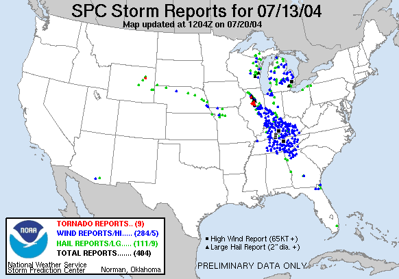
The summer season wasn't perfect though.  On the 13th of July, a derecho swept across the state bringing mass destruction.  A derecho is a large, organized line of thunderstorms often shaped like a bow that rapidly drops south across an area and typically causes serious wind damage.  The derecho that moved through Kentucky that night brought widespread 60-80 miles per hour winds.  The weather station at WKU recorded a gust of 84 miles per hour.  Louisville Gas and Electric reported that it caused the most power outages they had seen since the famous 1974 "super outbreak" of tornadoes.  Trees were snapped across a large area of the state and lots of property damage reports were sent to the National Weather Service office in Louisville from all over central Kentucky.  Check out the shear number of damage reports that came in that night.  We rarely see this much damage:


When fall came around the rains continued.  October was the 4th wettest ever recorded here, and even November had frequent rainfall.  The heavy rains of October and November turned into heavy snow in December.  Winter came in like the proverbial lion with a snowstorm that dropped two feet of accumulation near Louisville and caused many areas in that part of Kentucky to shut down completely.

Despite all the intense weather we saw in 2004, and the many records that were broken, it would be the summer period that would stay on the minds of Kentuckians for years to come.  The dry ground and summer heat and humidity that is a staple of life in our state during the longest days of the year never materialized, and it was like a refreshing gift from nature.  We have already seen readings above 90 degrees this year, but if you look at the year as a whole it has been very similar to 2004 in many ways.  Could summer shape up to be cooler and wetter than average here again?  There are many people who would be very thankful if it did, and I myself am one of them.


-Shawn


Some data assembled by the National Weather Service office, Louisville, Kentucky