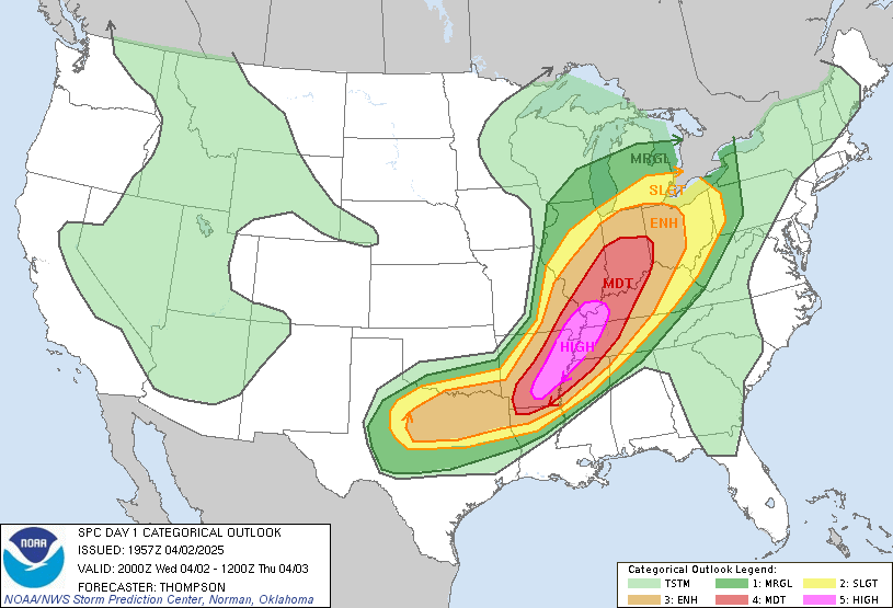
Upper level winds are not very high with this system, but it looks to me like helicity and shear values ARE high, as well as moisture and instability. So the ingredients are together for supercell type storms to develop, and those are the kind that can produce violent and long-lived tornadoes. This activity will affect western KY later this afternoon and may approach the I65 corridor by later tonight.
Please urge your family and friends to keep the weather radios on alert mode and stay tuned to the NWS website (www.weather.gov/louisville) if you are in an area away from weather radio access.
Just added: Here is a new look at the current outlook from SPC:
-Shawn
UPDATE:
SPC has upgraded western Kentucky to HIGH RISK for severe weather today. A deadly outbreak of tornadoes and wind damage is LIKELY just to our west. Central Kentucky is upgraded to Moderate Risk. Latest model data coming in reveals that much of Kentucky, southern Illinois, southern Indiana, and Tennessee could see destructive storms today and tonight. Here is the latest outlook:
Please take this seriously. Keep your NOAA weather radio on alert mode today and if you have any family or friends in the High Risk area, warn them to stay constantly alert to weather conditions. We do NOT need any more fatalities! We've had way too many this year already. More updates later...
-Shawn
The eastern half of the U.S. has been absolutely hammered by severe weather this season. This was predicted nearly two months ago (see this link: http://www.theandersonnews.com/content/very-active-severe-storm-season-could-be-shaping ) and unfortunately the prediction has been spot-on. We've also seen large cities such as Birmingham, Tuscaloosa, Minneapolis, and Joplin sustain massive damage and fatalities which is unusual. The severe weather train is still rolling and will flare up again on Wednesday and Thursday.
Here is the current convective outlook for Wednesday from the Storm Prediction Center:
The problem is that a low pressure center is forecast by the models to deepen in the Kansas vicinity and slowly work toward the Ohio Valley. This will pull even more moisture and wind into our area ahead of the low. Also, shear profiles as you increase in altitude will be very high. So the stage will be set for supercell type storms to form and track into Kentucky tomorrow. These could bring strong tornadoes with them for MO, AR, TN, KY, and IL.
It would be a great idea to keep a close eye on the weather tomorrow and monitor the NWS website or NOAA weather radio for watches and warnings as they are issued. It could get WILD around here, especially Wednesday evening.
I'll leave you with a picture of Joplin, MO, one of our border states. I hear that the damage there could exceed $3 Billion dollars...and that's not counting the loss of life which you can't put a price on. This tornado was the single deadliest tornado ever recorded in the U.S.! Take this weather seriously.
-Shawn


No comments:
Post a Comment